
ACTIVE STORM TRACK →
PROPERTY-INSURANCE CLAIM HELP FL CITIESSC CITIESGUIDESTATESNEWSSITE MAPABOUT
HurricaneLaw.Pro, Florida and South Carolina property insurance claim resource HURRICANELAW.PRO
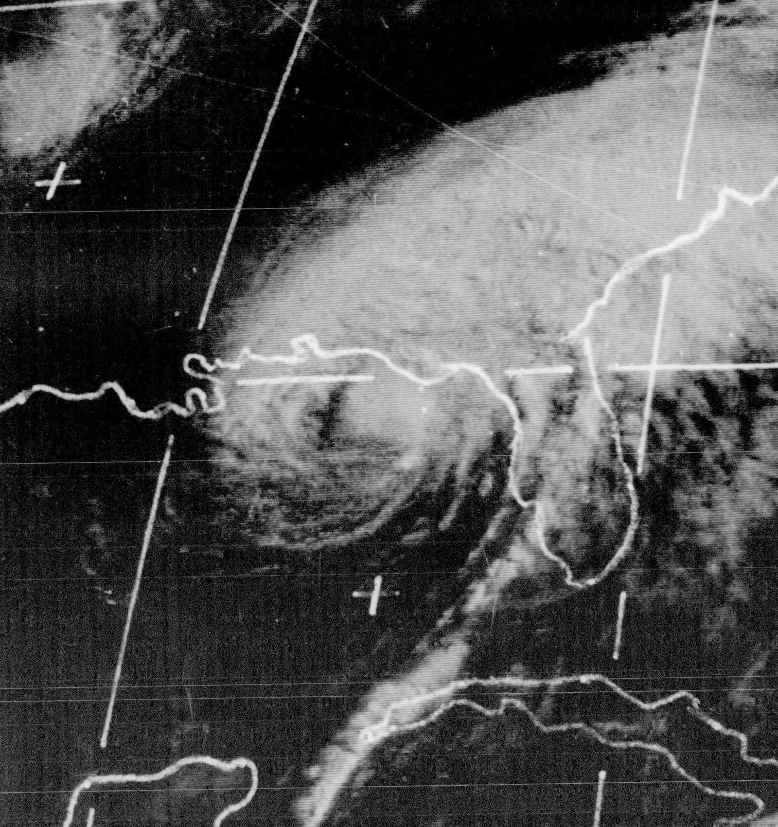
Agnes at peak intensity approaching the Florida Panhandle, June 19, 1972
STORM ARCHIVE / 1972 LANDFALL 30.1°N 85.7°W
CAT 1 FL · 1972 · 85 mph

Hurricane Agnes

Landfall: Near Panama City, FL Panhandle; second landfall near New York City as a tropical storm · 1972-06-19. Less than 1% of Agnes's insurable flood damage was covered, roughly 100,000 NFIP policies existed nationwide (FEMA), and Congress answered with the Flood Disaster Protection Act of 1973's mandatory purchase rule

NOAA / NHC (storm wallet archive)
AT LANDFALL
CAT 1
PEAK WIND
85 mph
PRESSURE
978 mb (FL landfall)
DAMAGE
$2.1B
DEATHS
128
01 THE PATH

Where it hit, start to finish

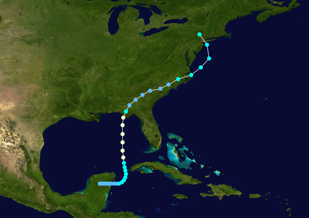
TRACK · HURRICANE AGNESNOAA (HURDAT best-track data)
Best track of Hurricane Agnes, June 14-23, 1972, a Category 1 at landfall whose worst work came a thousand miles north
Yucatán Channel / Gulf
JUNE FORMATION

Agnes formed off Yucatán June 14-16 and moved north through the Gulf, reaching hurricane strength, a large, ragged storm that never exceeded Category 1.

Panama City area, FL
FL PANHANDLE LANDFALL - 75 MPH

Landfall June 19 near Cape San Blas, southeast of Panama City, with winds near 75 mph after an 85 mph peak over the Gulf. Direct wind damage was modest, but Agnes threw a tornado outbreak across Florida that accounted for much of the state's damage and several deaths.

Georgia / Carolinas
INLAND WEAKENING, RE-INTENSIFICATION OFFSHORE

Agnes weakened to a depression over Georgia June 20-21, drifted to the Atlantic off North Carolina, and re-intensified as a tropical storm while merging with a non-tropical low.

New York City area
SECOND LANDFALL - JUNE 22

Agnes came ashore again near New York City June 22 as a tropical storm, then stalled and looped over Pennsylvania as its circulation combined with the low, parking a tropical rain machine over the Mid-Atlantic.

Wilkes-Barre / Harrisburg, PA
SUSQUEHANNA RECORD FLOOD

Up to 19 inches of rain fell on saturated ground. The Susquehanna crested at record levels; at Wilkes-Barre the river topped the city's levees, flooding the Wyoming Valley. Pennsylvania took the bulk of the storm's $2.1 billion damage, the costliest U.S. disaster to that date.

Elmira / Corning, NY and Richmond, VA
FLOODS ACROSS THREE STATES - 128 DEAD

The Chemung flooded Elmira and Corning; the James set a record crest at Richmond. Agnes killed 128 people, almost all by freshwater flooding, before dissipating June 23.

02 THE RECORD IN IMAGES
ALL IMAGERY U.S. GOV / PUBLIC DOMAIN
SATELLITE NOAA / NHC (storm wallet archive)
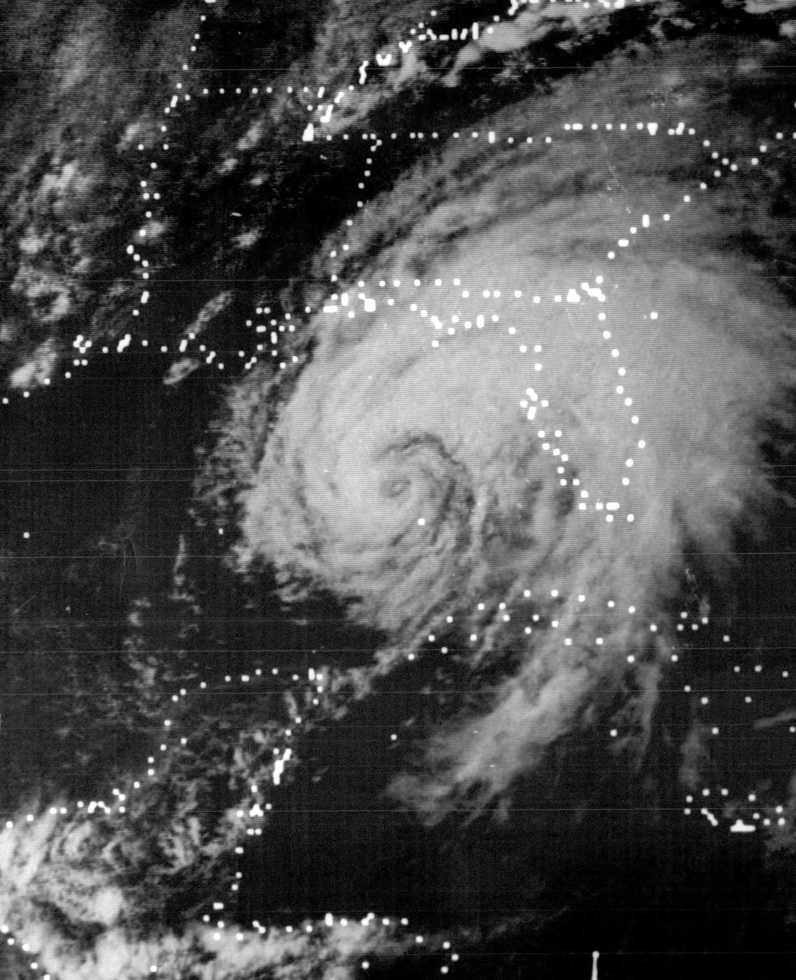
Agnes over the Gulf of Mexico, June 18, 1972, the day before Florida landfall

The storm

Agnes never looked like a catastrophe on the Saffir-Simpson scale. It formed off the Yucatán June 14-16, 1972, crossed the Gulf as a large, ragged Category 1 that peaked at 85 mph, and made landfall near Cape San Blas in the Florida Panhandle on June 19 with winds near 75 mph.

The Florida chapter was brief, modest wind damage plus a tornado outbreak across the peninsula. Agnes weakened to a depression over Georgia, drifted offshore of North Carolina, and re-intensified as a tropical storm while merging with a non-tropical low. It made a second landfall near New York City on June 22, then stalled and looped over Pennsylvania.

That stall was the disaster. Up to 19 inches of tropical rain fell on ground already saturated by a wet June. The Susquehanna, Chemung, Genesee, and James basins all went to record or near-record crests. Agnes killed 128 people, almost all by freshwater flooding far from the sea, and caused $2.1 billion in damage, the costliest U.S. disaster recorded to that date.
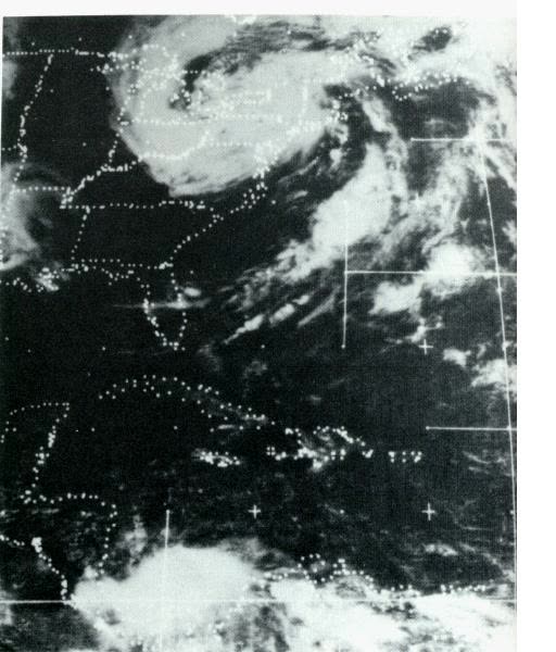
Agnes's remnants stalled over the Northeast, the rain machine that flooded the Susquehanna basin
Agnes's remnants stalled over the Northeast, the rain machine that flooded the Susquehanna basin NOAA

The damage

Pennsylvania absorbed the worst. At Wilkes-Barre the Susquehanna overtopped the levees protecting the Wyoming Valley, flooding thousands of homes and businesses to the rooflines. Harrisburg flooded, including the Governor's Mansion. Tens of thousands of Pennsylvania homes and businesses were damaged or destroyed, and hundreds of thousands of residents were driven out statewide.

In New York's Southern Tier, the Chemung River devastated Elmira and Corning. In Virginia, the James River crested at Richmond above every mark in two centuries of records. Florida's damage, wind and tornado, was a footnote in the national total.
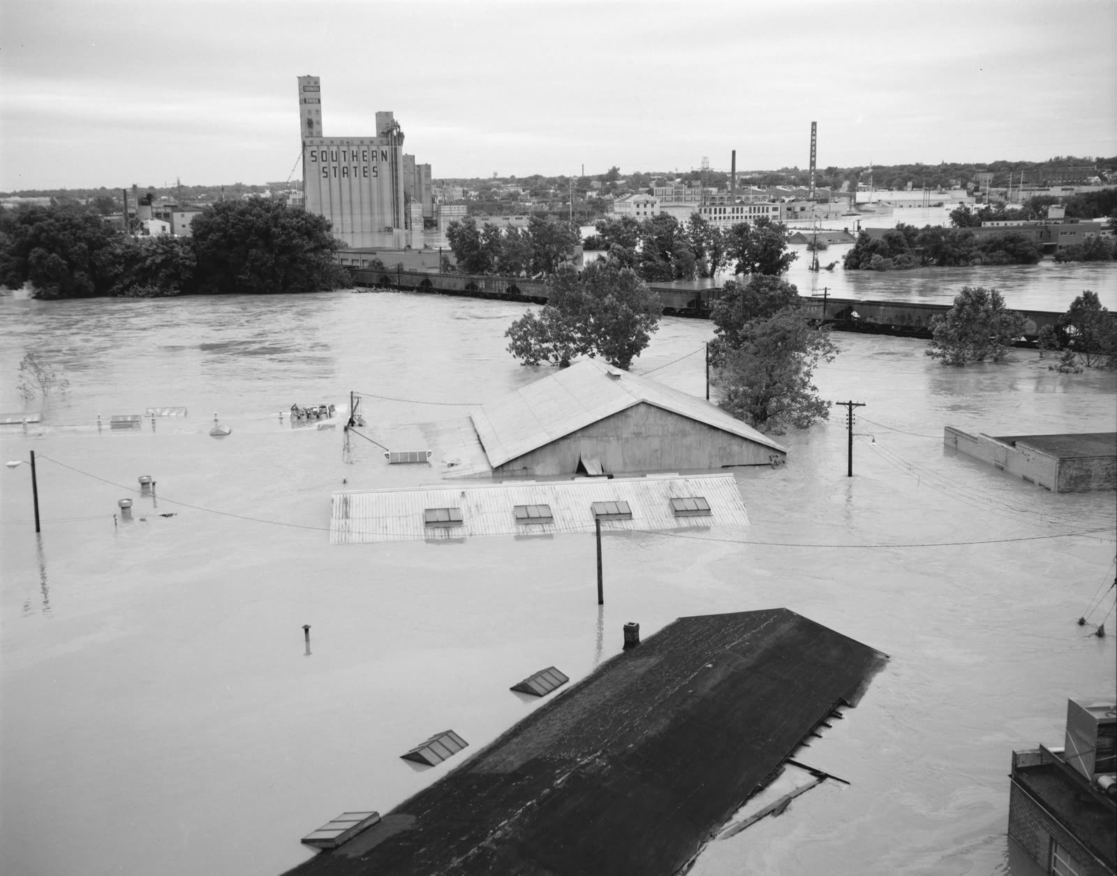
Richmond, VA under Agnes floodwater, the James River crested at a record set against 200 years of records
Richmond, VA under Agnes floodwater, the James River crested at a record set against 200 years of records Library of Virginia (no known restrictions)

The insurance aftermath

Agnes was the storm that exposed the National Flood Insurance Program as a program on paper. The NFIP was less than five years old in June 1972. Relatively few communities had joined, and roughly 100,000 flood policies were in force nationwide (FEMA). When the rivers crested, less than 1 percent of Agnes's insurable flood damage was covered. In Wilkes-Barre, the hardest-hit city in the country, two flood insurance policies had been sold.

Homeowners policies excluded flood then as now, so the claim files that existed were wind and tornado files, mostly in Florida. For the flooded Northeast, recovery ran on federal relief: disaster grants, and SBA disaster loans whose terms Congress sweetened after the fact for Agnes victims. The gap between $2.1 billion of damage and a rounding-error of flood premiums became the central exhibit in congressional hearings over the following year.

The legislative result was the Flood Disaster Protection Act of 1973. It converted the NFIP from a voluntary offer into a de facto mandate: flood insurance became a required condition of any federally related mortgage on property in a mapped Special Flood Hazard Area, and communities that declined to join the program forfeited federal disaster assistance for flood losses. Nearly every "your lender requires flood insurance" letter sent since 1973 traces to Agnes. Program participation, community floodplain mapping, and policy counts all inflected sharply upward after the Act, the structure under which every subsequent U.S. flood catastrophe, from Katrina to Helene, has been adjusted.
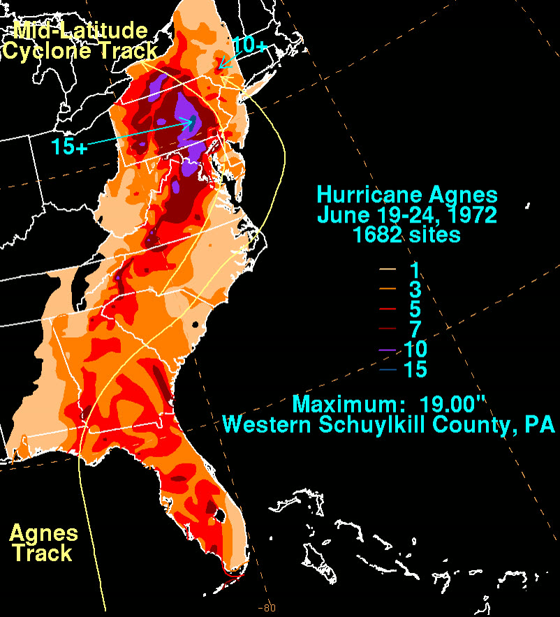
Agnes rainfall totals, up to 19 inches across Pennsylvania and New York on already-saturated ground
Agnes rainfall totals, up to 19 inches across Pennsylvania and New York on already-saturated ground NOAA / WPC (David Roth)

What policyholders learned

  • Category is not risk. A Category 1 at landfall produced the costliest disaster in U.S. history to that date, a thousand miles from the beach. Inland freshwater flood is a hurricane peril with no wind speed attached.
  • An available program is worthless unbought. The NFIP existed for five years before Agnes; Wilkes-Barre bought two policies. The mandatory-purchase rule exists because voluntary uptake failed.
  • The flood exclusion does not bend for river water. Agnes claims under homeowners policies were denied for the same surface-water language that denies surge claims at the coast. Only a flood policy responds.
  • Federal relief is a loan, not an indemnity. Agnes survivors rebuilt on SBA debt and capped grants, the default outcome for uninsured flood losses before and since.
  • Mapping determines mandates. Post-1973, coverage obligations follow the flood map. Policyholders who check their mapped zone, and the map's age; know their lender requirement and their real exposure before the water settles it.

Not legal advice; consult an attorney about your specific claim. Damage figures are nominal (not inflation-adjusted) unless noted.

AT LANDFALL · HURRICANE AGNES · 1972
85 mph
SUSTAINED WINDS
REPRESENTATIVE FOOTAGE
03 THE FULL RECORD

Every official record of Agnes

Reports, imagery archives, flood data, and claims records, straight from the agencies.

FREE CASE REVIEW · NO FEE UNLESS YOU RECOVER
Agnes claim denied?
CALL SC · 843-542-0454CALL FL · 813-588-0164FREE CLAIM REVIEW
RELATED GUIDES
HurricaneLaw.Pro, Florida and South Carolina property insurance claim resource HURRICANELAW.PRO

A comprehensive property-insurance claim resource for policyholders: denied and underpaid claims, coverage and bad-faith law, storm dossiers, carrier profiles, city guides, and the complete claims playbook. Florida and South Carolina.

▸ SEE THE FULL SITE MAP →
STORM ALERTS SOURCED FROM NOAA / NHC
SOUTH CAROLINA
496 Bramson Court, Suite 100
Mount Pleasant, SC 29464
CALL OR TEXT
FLORIDA
CALL OR TEXT
CLAIMS 9
BAD FAITH 7
DENIAL FILINGS
HOW CLAIMS GET DENIED
DENIAL DOCUMENTS
DENIALS, ANSWERED 9
COVERAGE 13
COMMERCIAL 8
ROOFS 8
TREES 5
DIRECTORIES
STORMS 51
WEATHER
NEWS & SITE 22
STORM ARCHIVE, CITIES & NEWS
Most recent below. Every storm dossier, city resource, and article is on its hub (linked at each heading) or the grouped site map →. All 73 carriers and 95 public-adjuster firms are in the Directories column above.
STORM ARCHIVE · 51 →
Hurricane Debby 2024Hurricane Helene 2024Hurricane Milton 2024Hurricane Idalia 2023Hurricane Ian 2022Hurricane Nicole 2022Hurricane Ida 2021Hurricane Laura 2020 View all 51 →
FLORIDA CITY RESOURCES · 37 →
Boca RatonBradentonCape CoralClearwaterCrestviewDaytona BeachDestinDunedin View all 37 →
SOUTH CAROLINA CITY RESOURCES · 8 →
BeaufortCharlestonColumbiaFlorenceGreenvilleHilton Head IslandMount PleasantMyrtle Beach
NEWS & UPDATES · 22 →

Coverage summaries, policy-language quotations, dollar figures, deadlines, and chart examples throughout this site are general information based on typical or standard policy forms and are illustrative only: they are not a quote, a guarantee of coverage, or a promise of any outcome. Every insurance policy is different: your own policy, endorsements, and state law control, so read your policy and confirm current statutes. Weather imagery courtesy of NOAA, the National Hurricane Center, and the National Weather Service. Legal services are provided by Halversen Law. Nothing on this site is legal advice; consult an attorney about your specific claim.

PrivacyTermsDisclaimerAboutContact
This site is not legal advice, and it is not a substitute for an attorney. Anything legal needs a licensed lawyer reading your policy and your facts. We recommend Halversen Law: the free claim review is the fastest way to get real eyes on your claim.
© 2026 HURRICANELAW.PRO · ALL RIGHTS RESERVED 27.9°N 82.5°W · ATLANTIC BASIN MONITOR
LAW FIRM
Halversen Law LICENSED · FLORIDA & SOUTH CAROLINA

Legal matters are handled by Halversen Law, a law firm licensed in Florida and South Carolina.

FREE CASE REVIEW