
ACTIVE STORM TRACK →
PROPERTY-INSURANCE CLAIM HELP FL CITIESSC CITIESGUIDESTATESNEWSSITE MAPABOUT
HurricaneLaw.Pro, Florida and South Carolina property insurance claim resource HURRICANELAW.PRO
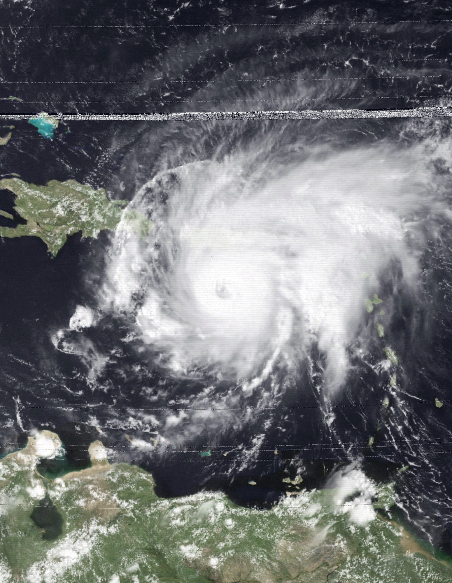
David near Category 5 peak intensity, 175 mph, 924 mb, approaching Hispaniola, August 30, 1979
STORM ARCHIVE / 1979 LANDFALL 31.5°N 81.2°W
CAT 2 AT LANDFALL PEAK CAT 5 SC & FL · 1979 · 175 mph

Hurricane David

Landfall: Near Blackbeard Island, GA (eye over Savannah; Hilton Head impact) · 1979-09-04. About 400,000 people evacuated the Southeast coast ahead of David, the first mass-evacuation test of the modern South Carolina shoreline

NOAA / NESDIS
AT LANDFALL
CAT 2
PEAK INTENSITY
CAT 5 · 175 mph
PRESSURE
924 mb (peak)
DAMAGE
~$320M US
DEATHS
2,068 total (15 US)
01 THE PATH

Where it hit, start to finish

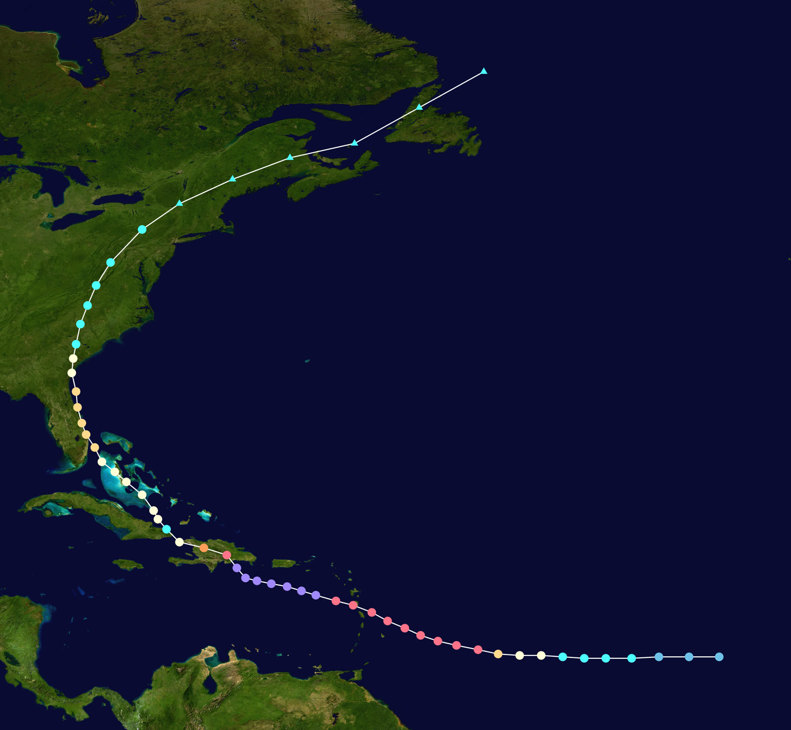
TRACK · HURRICANE DAVIDNOAA / NHC (best-track data)
Best track and Saffir-Simpson intensity of Hurricane David, August 25-September 8, 1979
Dominica
CAT 5 STRIKE - ISLAND CRIPPLED

David crossed Dominica on August 29, 1979 near peak intensity, killing 56 and leaving most of the island's population homeless, one of the worst hurricane disasters in the island's history.

Santo Domingo, Dominican Republic
~2,000 DEAD

The eye passed near Santo Domingo on August 31 as a 175-mph Category 5 with 924 mb pressure. About 2,000 people died in the Dominican Republic, most in flooding and structural collapses.

West Palm Beach, FL
FIRST US LANDFALL - CAT 2

Weakened by Hispaniola's mountains, David brushed ashore near West Palm Beach on September 3 as a Category 2, then hugged the Florida coast northward, the first hurricane warning for much of the Southeast since 1964's Cleo era.

Blackbeard Island / Savannah, GA
SECOND US LANDFALL - EYE OVER SAVANNAH

Landfall near Blackbeard Island the afternoon of September 4 as a Category 2; the eye crossed the Savannah metro area around 5 p.m. EST. Savannah Airport measured 58 mph sustained, gusts to 68 mph, and 6.86 inches of rain; about 70,000 customers lost power, some for weeks. David remains the last hurricane to score a direct hit on Savannah.

Hilton Head / SC Lowcountry
GUSTS TO 70 MPH, 5 TORNADOES

Hilton Head gusted to 70 mph as David moved into South Carolina with very high tides, dangerous surf, and heavy rain. At least five tornadoes touched down; SC damage ran about $10 million with extensive beach erosion.

Northeast US
EXTRATROPICAL FINISH

David weakened to a tropical storm over the Carolinas and became a strong extratropical cyclone over the Northeast; Mt. Washington, NH gusted to 174 mph. Final toll: about 2,068 deaths and $320 million in US damage.

02 THE RECORD IN IMAGES
ALL IMAGERY U.S. GOV / PUBLIC DOMAIN
SATELLITE NOAA / NESDIS
Satellite loop of David striking the Dominican Republic as a Category 5, about 2,000 died there

The storm

David formed southeast of Cape Verde on August 25, 1979 and became one of the strongest hurricanes of the satellite era: a Category 5 with 175 mph winds and 924 mb pressure. It crossed Dominica near peak strength on August 29, then put its eye near Santo Domingo on August 31, killing about 2,000 people in the Dominican Republic.

Hispaniola's mountains broke the storm's core. David limped north, brushed ashore near West Palm Beach on September 3 as a Category 2, then ran up the Florida coastline just offshore. Its second U.S. landfall came near Blackbeard Island, Georgia, on the afternoon of September 4 as a Category 2, and the eye crossed the Savannah metro area around 5 p.m. EST before moving into the South Carolina Lowcountry with high winds, heavy rain, tornadoes, very high tides, and dangerous surf.

Total toll: roughly 2,068 deaths, 15 of them in the United States, and $1.54 billion in damage, about $320 million of it American.
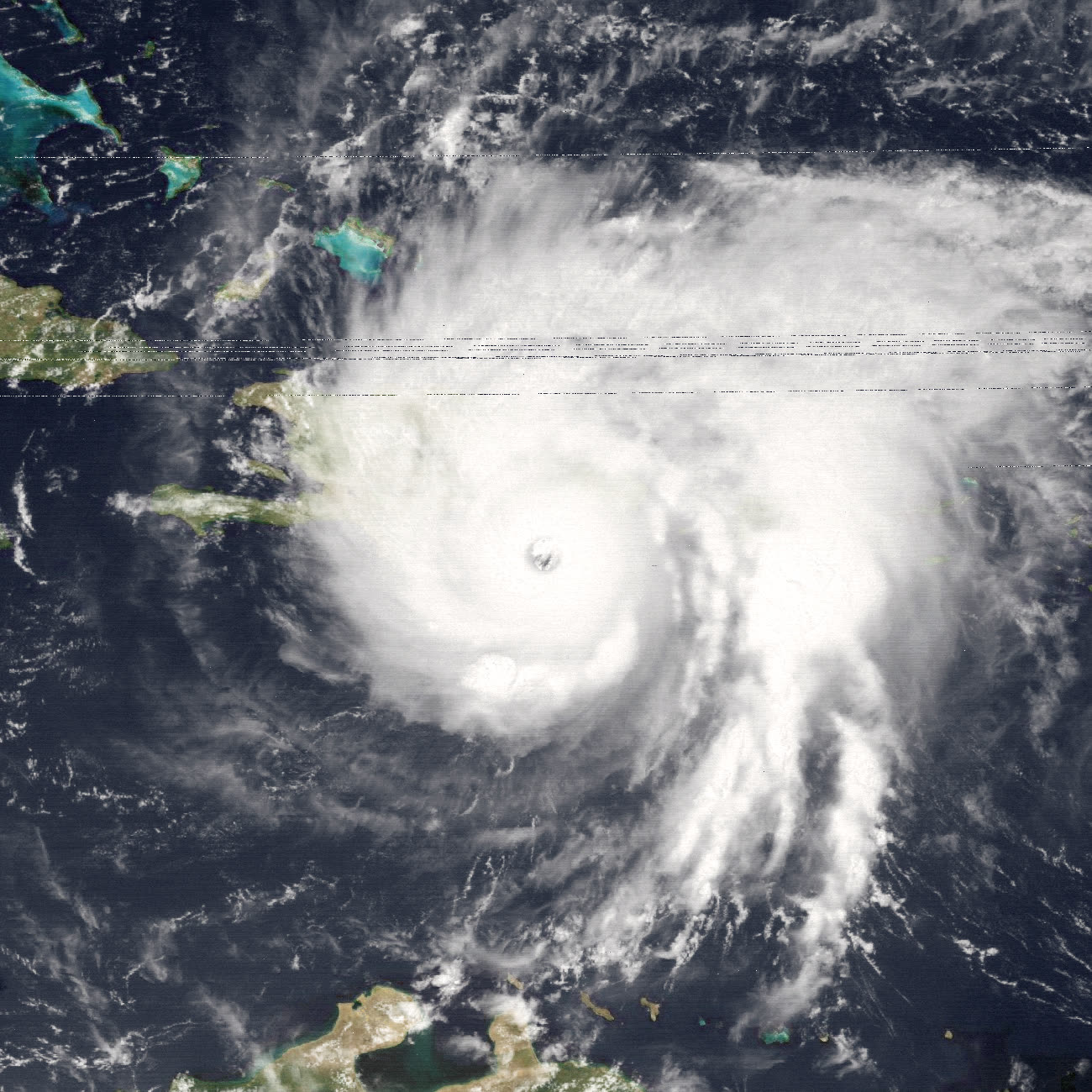
David emerging north of Hispaniola, August 31, 1979, weakened by the island's mountains but re-organizing toward Florida
David emerging north of Hispaniola, August 31, 1979, weakened by the island's mountains but re-organizing toward Florida NOAA / NESDIS

The damage

Around Savannah, David's last direct hurricane hit to this day, winds of 58 mph sustained and gusts to 68 mph at the airport downed trees and power lines throughout the metro area; about 70,000 customers lost power, with outages lasting weeks in places. Two people drowned in heavy surf at Jekyll Island. Georgia damage ran about $5 million.

In South Carolina the storm's northeast quadrant delivered gusts to 70 mph at Hilton Head, 6.76 inches of rain at Charleston, at least five tornadoes, coastal flooding on very high tides, and extensive beach erosion. State damage totaled about $10 million, mostly roofs, trees onto structures, docks, and eroded oceanfront.

The larger American story was the evacuation. With a Category 5 in the news for a week and warnings stretching from Florida to the Carolinas, roughly 400,000 people left the Southeast coast, at the time one of the largest hurricane evacuations on record, and the first true test of clearing the modern, built-out SC coast, including a Hilton Head that had grown from near-empty in Gracie's era to a major resort island.
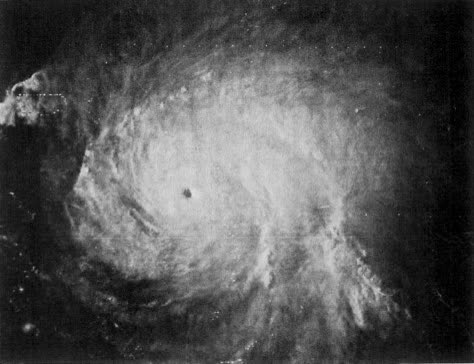
SMS-2 visible image of David at 2031 UTC August 29, 1979, shortly before devastating Dominica and the Dominican Republic
SMS-2 visible image of David at 2031 UTC August 29, 1979, shortly before devastating Dominica and the Dominican Republic NOAA / NESDIS

The insurance aftermath

David's U.S. claims were a high-volume, low-severity event: tens of thousands of wind claims for shingles, fences, signage, docks, and tree strikes across three states, nearly all inside standard homeowners wind coverage. The chronic dispute lines were already visible, depreciation holdbacks on aging roofs, tree-removal caps, and erosion losses (land and beach are not covered property), but with $320 million spread across the Southeast, carriers paid and moved on. Federal help arrived through the brand-new FEMA, created by executive order less than five months earlier; David and Frederic, striking two weeks apart, were the agency's first major hurricane activations.

The evacuation mattered more than the payout. Four hundred thousand people moved off the coast on the strength of satellite tracking and NHC warnings, and losses stayed a fraction of what the Caribbean suffered. Emergency managers took David as proof-of-concept; insurers took it as evidence that the newly developed Southeast coast could be warned in time, an assumption about exposure that stood until Hugo struck the same Lowcountry ten years later at Category 4 and produced roughly $4 billion in insured losses.

For South Carolina policyholders, David was the decade's dress rehearsal: the first time the modern Hilton Head-to-Charleston coast filed hurricane claims at any scale, and a preview of the wind-deductible and erosion questions Hugo would ask with force.
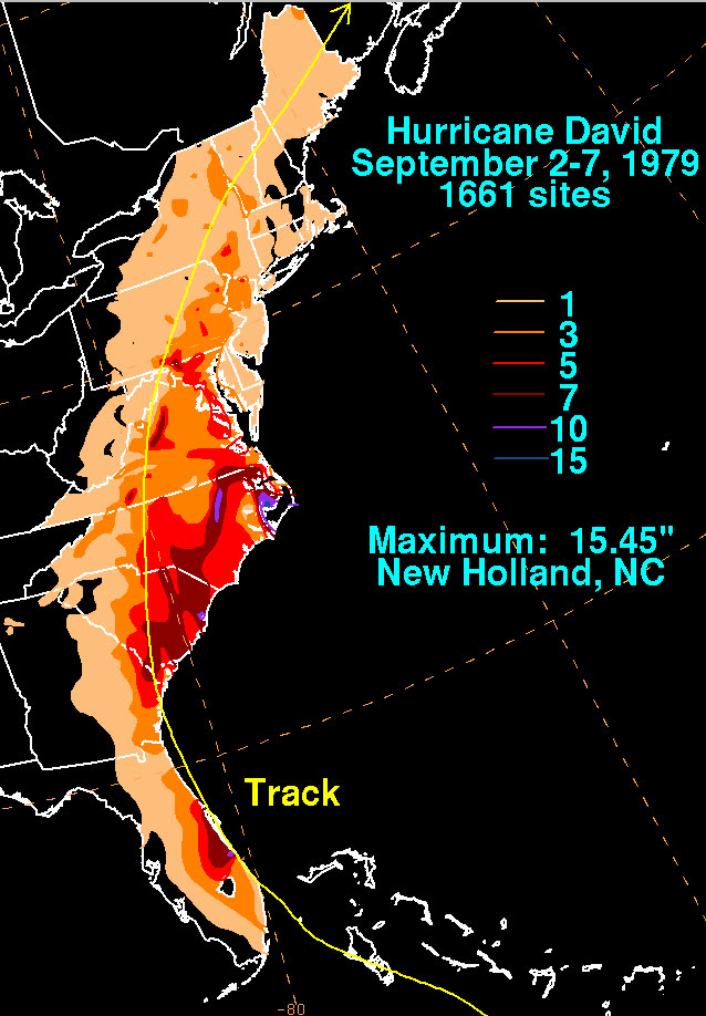
David's U.S. rainfall footprint, 6.86 inches at Savannah, 6.76 at Charleston, flooding rains up the East Coast
David's U.S. rainfall footprint, 6.86 inches at Savannah, 6.76 at Charleston, flooding rains up the East Coast NOAA / WPC

What policyholders learned

  • Weakened storms still generate full claim files. A post-Caribbean Category 2 produced weeks-long outages, thousands of tree and roof claims, and $10 million in SC losses. Coverage questions do not scale down with category.
  • Erosion and land loss are not covered perils. David's worst SC coastal damage was eroded beachfront, excluded then and now. Structures are insured; the land under them is not.
  • Tornadoes inside a hurricane are wind claims. The five SC tornadoes were covered wind events, but attribution matters for deductibles where hurricane deductibles apply, documentation of tornado damage can change which deductible governs.
  • Food spoilage and outage losses need policy support. Multi-week power outages produced spoilage and additional-living-expense claims; policies pay these only within specific sublimits and triggers worth checking before the season.
  • Evacuation costs come out of pocket unless documented. Additional living expense coverage generally requires a mandatory order and proof the home was uninhabitable or under order, receipts from the 400,000 who left settled those claims.

Not legal advice; consult an attorney about your specific claim. Damage figures are nominal (not inflation-adjusted) unless noted.

AT LANDFALL · HURRICANE DAVID · 1979
175 mph
SUSTAINED WINDS
REPRESENTATIVE FOOTAGE
03 THE FULL RECORD

Every official record of David

Reports, imagery archives, flood data, and claims records, straight from the agencies.

FREE CASE REVIEW · NO FEE UNLESS YOU RECOVER
David claim denied?
CALL SC · 843-542-0454CALL FL · 813-588-0164FREE CLAIM REVIEW
RELATED GUIDES
HurricaneLaw.Pro, Florida and South Carolina property insurance claim resource HURRICANELAW.PRO

A comprehensive property-insurance claim resource for policyholders: denied and underpaid claims, coverage and bad-faith law, storm dossiers, carrier profiles, city guides, and the complete claims playbook. Florida and South Carolina.

▸ SEE THE FULL SITE MAP →
STORM ALERTS SOURCED FROM NOAA / NHC
SOUTH CAROLINA
496 Bramson Court, Suite 100
Mount Pleasant, SC 29464
CALL OR TEXT
FLORIDA
CALL OR TEXT
CLAIMS 9
BAD FAITH 7
DENIAL FILINGS
HOW CLAIMS GET DENIED
DENIAL DOCUMENTS
DENIALS, ANSWERED 9
COVERAGE 13
COMMERCIAL 8
ROOFS 8
TREES 5
DIRECTORIES
STORMS 51
WEATHER
NEWS & SITE 22
STORM ARCHIVE, CITIES & NEWS
Most recent below. Every storm dossier, city resource, and article is on its hub (linked at each heading) or the grouped site map →. All 73 carriers and 95 public-adjuster firms are in the Directories column above.
STORM ARCHIVE · 51 →
Hurricane Debby 2024Hurricane Helene 2024Hurricane Milton 2024Hurricane Idalia 2023Hurricane Ian 2022Hurricane Nicole 2022Hurricane Ida 2021Hurricane Laura 2020 View all 51 →
FLORIDA CITY RESOURCES · 37 →
Boca RatonBradentonCape CoralClearwaterCrestviewDaytona BeachDestinDunedin View all 37 →
SOUTH CAROLINA CITY RESOURCES · 8 →
BeaufortCharlestonColumbiaFlorenceGreenvilleHilton Head IslandMount PleasantMyrtle Beach
NEWS & UPDATES · 22 →

Coverage summaries, policy-language quotations, dollar figures, deadlines, and chart examples throughout this site are general information based on typical or standard policy forms and are illustrative only: they are not a quote, a guarantee of coverage, or a promise of any outcome. Every insurance policy is different: your own policy, endorsements, and state law control, so read your policy and confirm current statutes. Weather imagery courtesy of NOAA, the National Hurricane Center, and the National Weather Service. Legal services are provided by Halversen Law. Nothing on this site is legal advice; consult an attorney about your specific claim.

PrivacyTermsDisclaimerAboutContact
This site is not legal advice, and it is not a substitute for an attorney. Anything legal needs a licensed lawyer reading your policy and your facts. We recommend Halversen Law: the free claim review is the fastest way to get real eyes on your claim.
© 2026 HURRICANELAW.PRO · ALL RIGHTS RESERVED 27.9°N 82.5°W · ATLANTIC BASIN MONITOR
LAW FIRM
Halversen Law LICENSED · FLORIDA & SOUTH CAROLINA

Legal matters are handled by Halversen Law, a law firm licensed in Florida and South Carolina.

FREE CASE REVIEW