
ACTIVE STORM TRACK →
PROPERTY-INSURANCE CLAIM HELP FL CITIESSC CITIESGUIDESTATESNEWSSITE MAPABOUT
HurricaneLaw.Pro, Florida and South Carolina property insurance claim resource HURRICANELAW.PRO
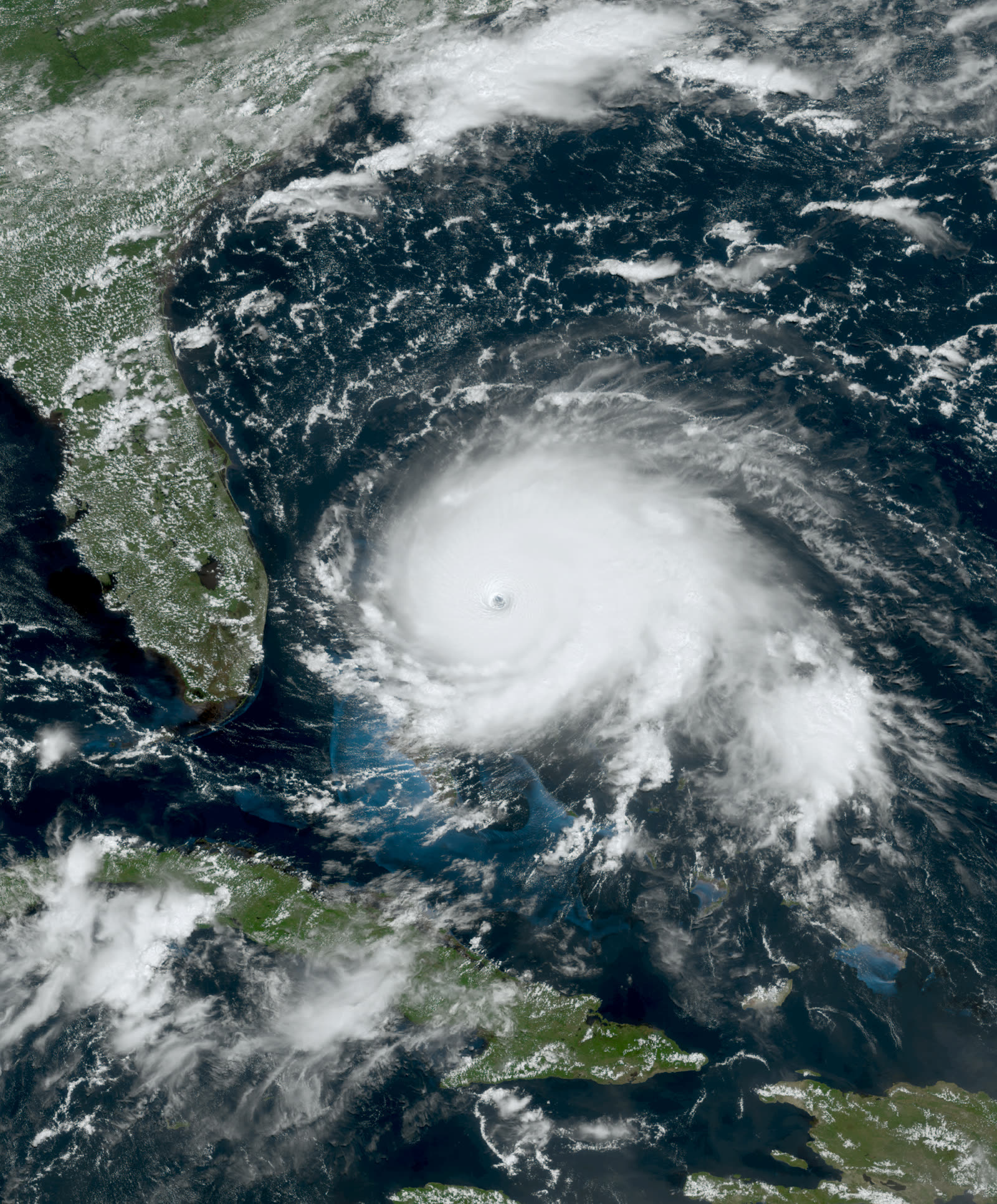
Dorian at Category 5 intensity, 185 mph, over Great Abaco, Bahamas, September 1, 2019
STORM ARCHIVE / 2019 LANDFALL 35.2°N 75.5°W (Cape Hatteras landfall)
OFFSHORE SC · 2019 · 185 mph

Hurricane Dorian

No SC landfall, closest approach off Charleston; later Cape Hatteras, NC (Cat 1) · 2019-09-06. Dorian never touched South Carolina, but it closed the coast for a week, proving that business-interruption and evacuation losses rarely collect without physical damage

NOAA / NESDIS (GOES-16)
CLASSIFICATION
OFFSHORE
PEAK WIND
185 mph
PRESSURE
910 mb (peak)
STORM SURGE
4-7 ft
DAMAGE
$1.6B (US)
DEATHS
10 (US)
01 THE PATH

Where it hit, start to finish

OFFSHORE TRACK · HURRICANE DORIANNOAA / NHC (best-track data)
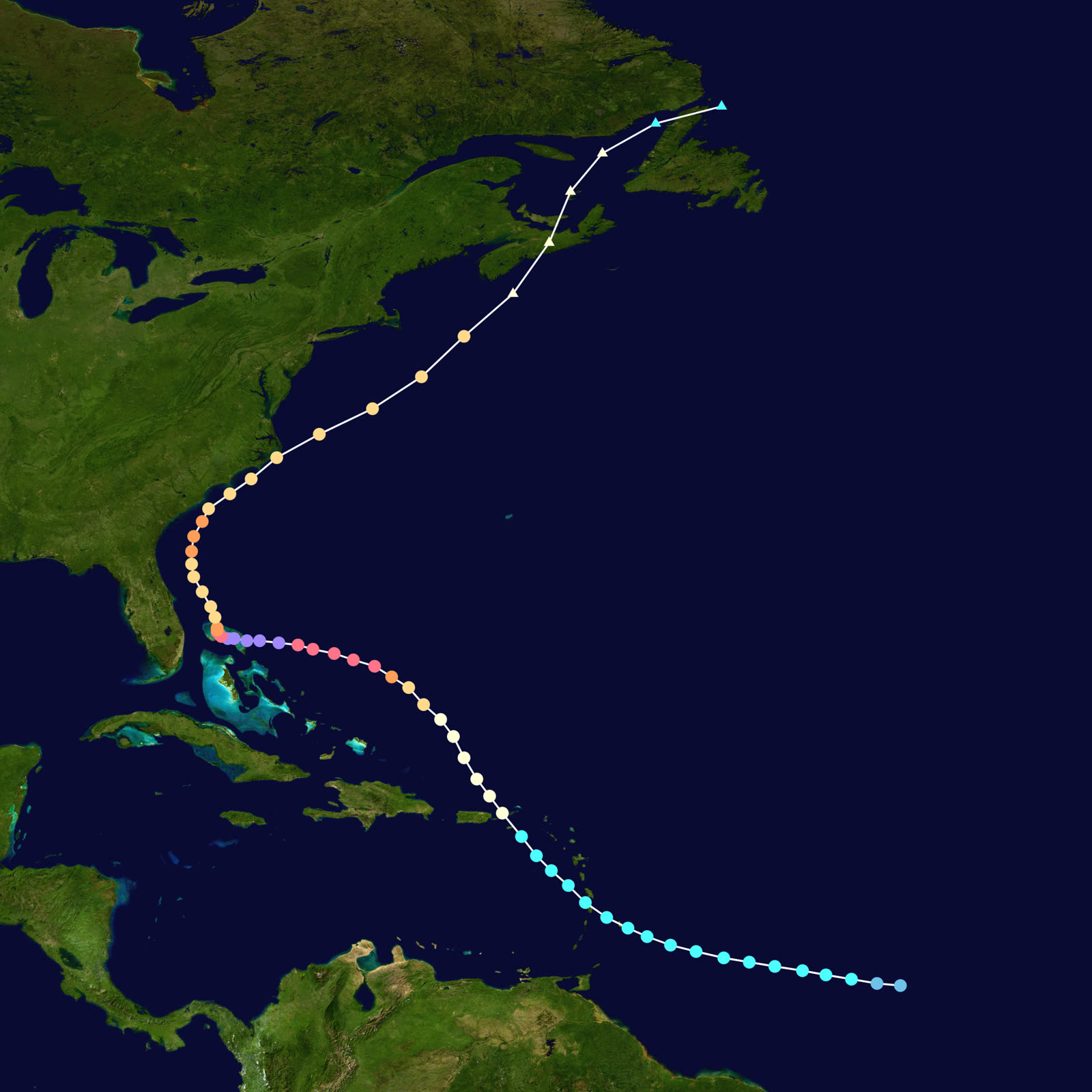
Best track of Hurricane Dorian, August 24 - September 10, 2019, a coast-parallel track that never touched Florida, Georgia, or South Carolina
Great Abaco / Grand Bahama
CAT 5 - 185 MPH - STALLED 24+ HOURS

Dorian struck Great Abaco September 1 at 185 mph with a 910 mb pressure, tying the strongest Atlantic landfall on record, then stalled over Grand Bahama for about a day. Bahamas toll: 74+ confirmed dead, hundreds missing, roughly $3.4 billion in damage.

Off the Florida coast
THE TURN

Forecast for days as a potential Florida Cat 4 hit, Dorian instead weakened and turned north September 3-4, paralleling the coast 60-100 miles offshore. Florida, Georgia, and the Carolinas had ordered mass evacuations, South Carolina's order covered the entire coast, with I-26 lane reversals out of Charleston.

Off Charleston, SC
CLOSEST APPROACH - SEPT 5

Dorian passed within roughly 50-70 miles of Charleston as a Category 2-3. Hurricane-force gusts, 6-10 inches of rain, and surge on a high tide pushed Charleston Harbor to a 10.3-ft total water level, third highest on record behind Hugo (1989) and 1940. About 270,000 SC customers lost power; tornadoes touched down in the Grand Strand.

Cape Hatteras, NC
ONLY US LANDFALL - CAT 1

Landfall at Cape Hatteras September 6 with 90 mph winds. Soundside surge flooded Ocracoke Island to record depths, stranding hundreds; an outbreak of more than 20 tornadoes hit eastern NC, including an EF2 at Emerald Isle.

Atlantic Canada
POST-TROPICAL EXIT

Dorian raced northeast and struck Nova Scotia September 7-8 as a powerful post-tropical cyclone. U.S. toll: 10 deaths and about $1.6 billion in damage, nearly all of it from a storm that made one Cat 1 landfall on a barrier island.

02 THE RECORD IN IMAGES
ALL IMAGERY U.S. GOV / PUBLIC DOMAIN
SATELLITE NASA (Worldview)
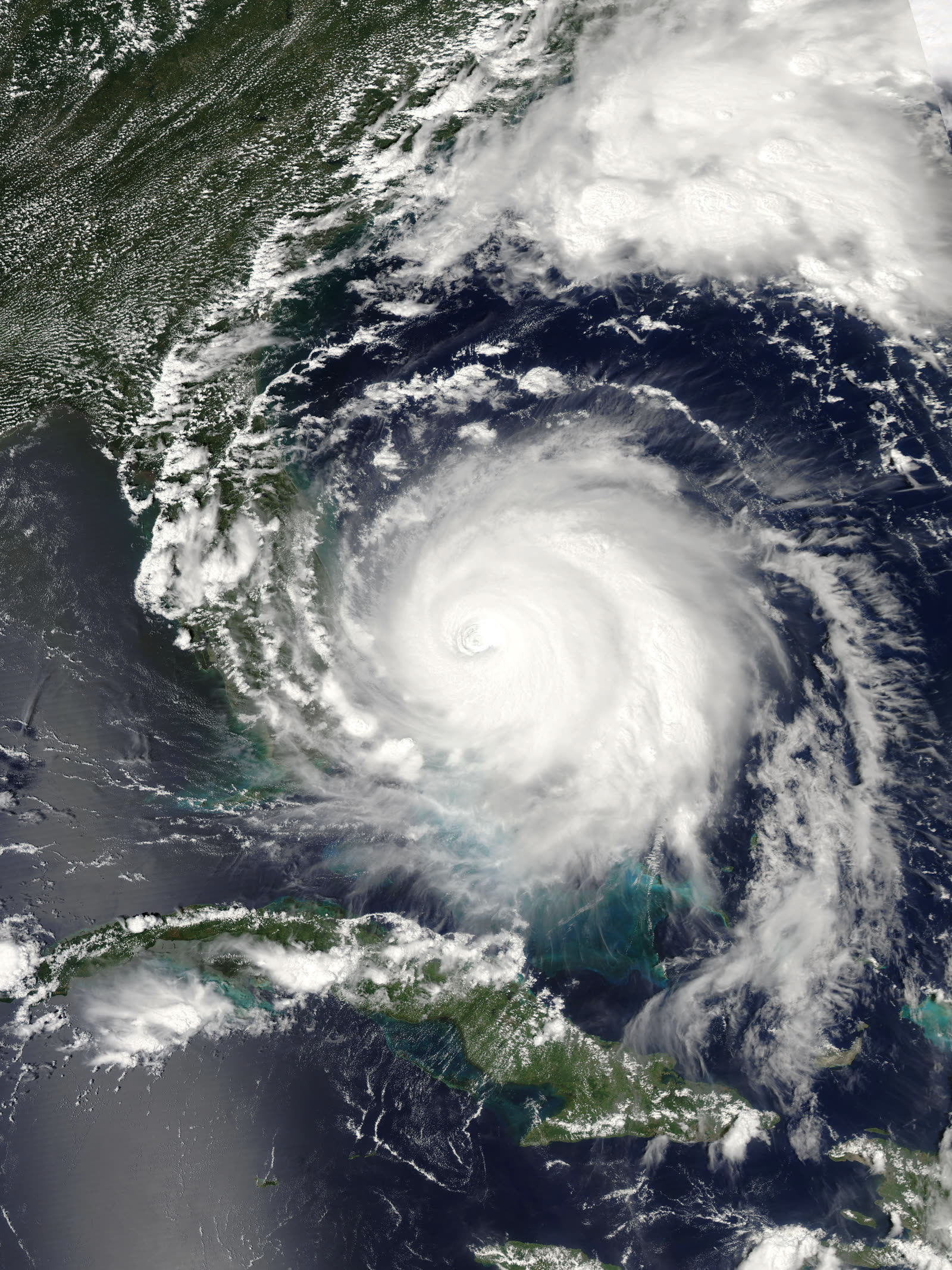
Dorian stalled over Grand Bahama, September 2, 2019, the storm sat on the island for roughly a day

The storm

Dorian became one of the most powerful Atlantic hurricanes ever observed, and South Carolina's encounter with it happened entirely offshore. The storm struck Great Abaco, Bahamas, on September 1, 2019, at 185 mph with a 910 mb pressure, tying the strongest Atlantic landfall on record, then stalled over Grand Bahama for a day. The Bahamas counted 74+ confirmed dead, hundreds missing, and about $3.4 billion in damage.

For days, forecasts had shown a potential Category 4 Florida landfall. Instead Dorian turned north on September 3-4 and ran parallel to the Southeast coast, 60-100 miles out. It passed closest to Charleston on September 5 as a Category 2-3, made its only U.S. landfall at Cape Hatteras, North Carolina, on September 6 as a Category 1, and struck Nova Scotia as a post-tropical cyclone two days later.

U.S. toll: 10 deaths and about $1.6 billion in damage, nearly all of it from a storm that never crossed the Florida, Georgia, or South Carolina coastline.
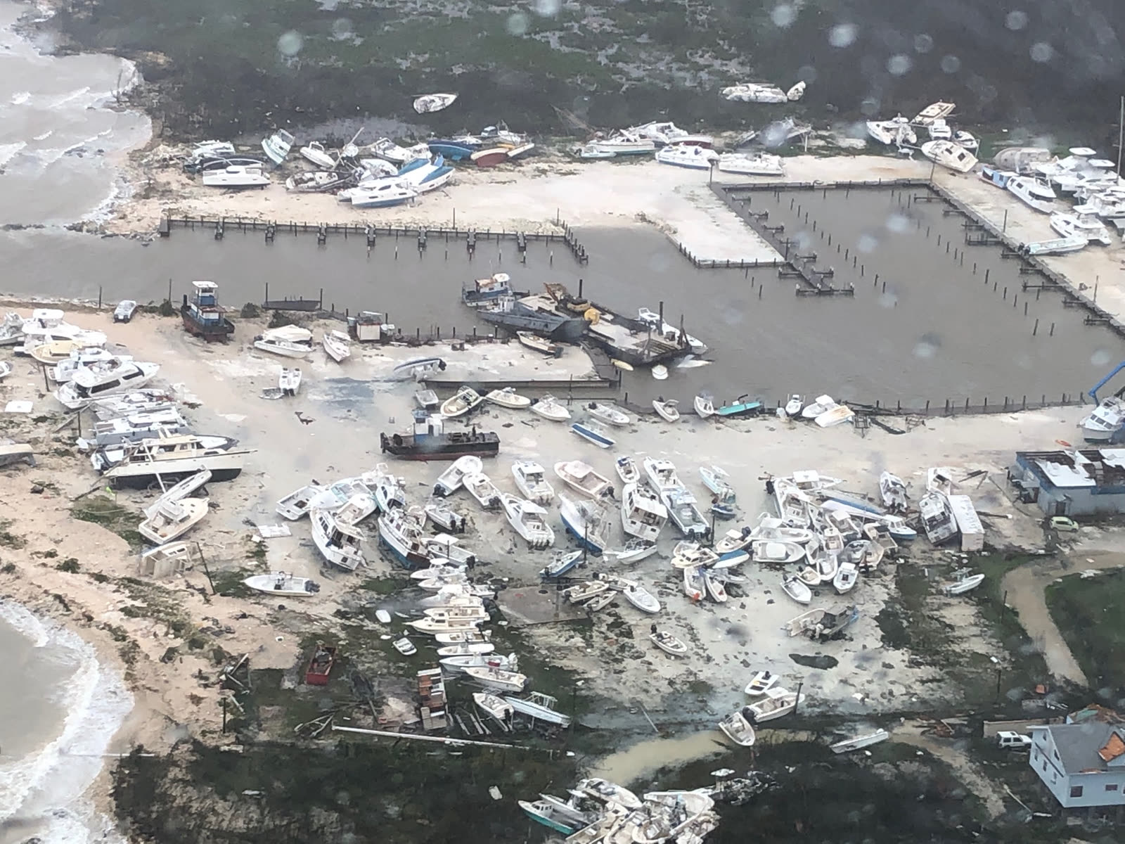
Coast Guard overflight of Marsh Harbour, Abaco, Bahamas damage reached $3.4 billion with 74+ confirmed dead
Coast Guard overflight of Marsh Harbour, Abaco, Bahamas damage reached $3.4 billion with 74+ confirmed dead U.S. Coast Guard

The damage

South Carolina took a real hit from a miss. Hurricane-force gusts and 6-10 inches of rain raked the coast; surge arriving on a high tide drove Charleston Harbor to a 10.3-foot total water level, third highest on record, behind Hugo (1989) and 1940. Downtown Charleston streets flooded, roughly 270,000 customers lost power statewide, tornadoes touched down in the Grand Strand, and falling trees produced scattered roof and structure losses inland.

North Carolina fared worse: soundside surge flooded Ocracoke Island to record depths and stranded hundreds, and an outbreak of more than 20 tornadoes included an EF2 at Emerald Isle. Before any of that, the entire SC coast, about 830,000 people, had been ordered to evacuate, with I-26 lane reversals out of Charleston, and coastal businesses closed for much of Labor Day week.

CBP overflight of the cruise ship Grand Celebration running evacuation relief from Grand Bahama
CBP overflight of the cruise ship Grand Celebration running evacuation relief from Grand Bahama U.S. Customs and Border Protection

The insurance aftermath

Catastrophe modelers put U.S. insured losses between $500 million and $1.6 billion, light for a storm of Dorian's size, because the wind core stayed at sea. The claims that were filed were conventional: wind, fallen trees, roofs, tidal flooding in Charleston, tornado losses in both Carolinas. Those largely paid, subject to the usual hurricane-deductible and tree-removal-cap frictions.

Dorian's real insurance lesson was what did not pay. A week-long coastal shutdown, mandatory evacuation, closed hotels and restaurants at the end of peak season, interrupted supply and payroll, generated substantial economic losses with little or no physical damage behind them. Standard business-interruption coverage requires direct physical loss to the insured property; evacuation orders, lost bookings, and preemptive closures do not qualify by themselves. Civil-authority coverage, the extension businesses reached for, typically requires physical damage near the insured premises that caused the government order, plus waiting periods measured in days against a shutdown measured in days. Policyholders argued the surge flooding and tornado damage in the region satisfied the damage trigger; carriers responded that South Carolina's evacuation was ordered September 2, three days before any SC damage existed, as a precaution against a forecast. Most such claims closed without payment.

Homeowners saw a smaller version: evacuation costs (travel, lodging, lost food) are generally not covered absent physical damage to the home or a policy's specific civil-authority/loss-of-use trigger. Dorian became the reference storm for a structural gap, forecast-driven losses from a storm that misses, that standard property insurance was never built to cover, and that parametric and event-triggered products now market against.
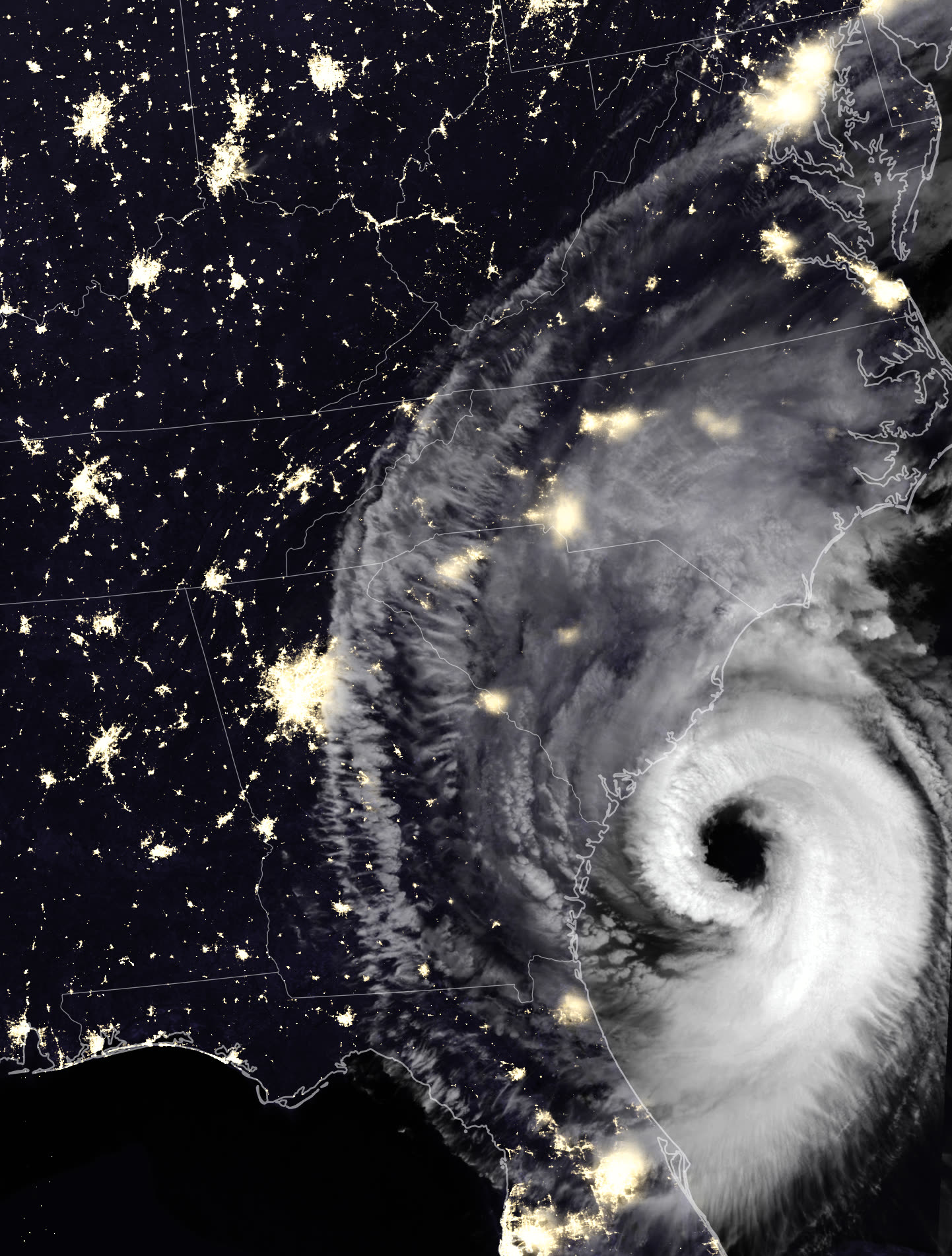
Dorian raking the South Carolina coast from offshore, September 5, 2019, wind, rain, surge, and tornadoes without landfall
Dorian raking the South Carolina coast from offshore, September 5, 2019, wind, rain, surge, and tornadoes without landfall NASA Earth Observatory (Suomi NPP / VIIRS)

What policyholders learned

  • No physical damage, no BI claim; read the trigger before relying on it. Businesses that assumed "hurricane closed us down" equaled coverage learned the direct-physical-loss requirement the expensive way.
  • Civil-authority coverage is narrow and clock-driven. It needs qualifying nearby damage, a causal government order, and survives its waiting period and day limits. An evacuation ordered off a forecast usually fails the sequence.
  • Tidal flooding is flood. Charleston's 10.3-ft harbor water level put saltwater in streets and ground floors; homeowners policies excluded it. Coastal SC properties needed flood coverage for a storm that stayed 60 miles out.
  • Offshore storms still produce ordinary wind claims. Gust, tree, and roof losses across the SC coast paid as standard hurricane claims, documentation, deductible math, and tree-removal sublimits worked exactly as in a landfall event.
  • Forecast risk is uninsured by default. Evacuation costs and lost revenue from a near-miss sit outside standard policies. Businesses exposed to shutdown-by-forecast now weigh parametric or event-based covers priced for exactly the Dorian scenario.

Not legal advice; consult an attorney about your specific claim. Damage figures are nominal (not inflation-adjusted) unless noted.

AT LANDFALL · HURRICANE DORIAN · 2019
4-7 ft; 10.3-ft total water level at Charleston Harbor, third highest on record
OF STORM SURGE · NC COAST
REPRESENTATIVE FOOTAGE
03 THE FULL RECORD

Every official record of Dorian

Reports, imagery archives, flood data, and claims records, straight from the agencies.

FREE CASE REVIEW · NO FEE UNLESS YOU RECOVER
Dorian claim denied?
CALL SC · 843-542-0454CALL FL · 813-588-0164FREE CLAIM REVIEW
RELATED GUIDES
HurricaneLaw.Pro, Florida and South Carolina property insurance claim resource HURRICANELAW.PRO

A comprehensive property-insurance claim resource for policyholders: denied and underpaid claims, coverage and bad-faith law, storm dossiers, carrier profiles, city guides, and the complete claims playbook. Florida and South Carolina.

▸ SEE THE FULL SITE MAP →
STORM ALERTS SOURCED FROM NOAA / NHC
SOUTH CAROLINA
496 Bramson Court, Suite 100
Mount Pleasant, SC 29464
CALL OR TEXT
FLORIDA
CALL OR TEXT
CLAIMS 9
BAD FAITH 7
DENIAL FILINGS
HOW CLAIMS GET DENIED
DENIAL DOCUMENTS
DENIALS, ANSWERED 9
COVERAGE 13
COMMERCIAL 8
ROOFS 8
TREES 5
DIRECTORIES
STORMS 51
WEATHER
NEWS & SITE 22
STORM ARCHIVE, CITIES & NEWS
Most recent below. Every storm dossier, city resource, and article is on its hub (linked at each heading) or the grouped site map →. All 73 carriers and 95 public-adjuster firms are in the Directories column above.
STORM ARCHIVE · 51 →
Hurricane Debby 2024Hurricane Helene 2024Hurricane Milton 2024Hurricane Idalia 2023Hurricane Ian 2022Hurricane Nicole 2022Hurricane Ida 2021Hurricane Laura 2020 View all 51 →
FLORIDA CITY RESOURCES · 37 →
Boca RatonBradentonCape CoralClearwaterCrestviewDaytona BeachDestinDunedin View all 37 →
SOUTH CAROLINA CITY RESOURCES · 8 →
BeaufortCharlestonColumbiaFlorenceGreenvilleHilton Head IslandMount PleasantMyrtle Beach
NEWS & UPDATES · 22 →

Coverage summaries, policy-language quotations, dollar figures, deadlines, and chart examples throughout this site are general information based on typical or standard policy forms and are illustrative only: they are not a quote, a guarantee of coverage, or a promise of any outcome. Every insurance policy is different: your own policy, endorsements, and state law control, so read your policy and confirm current statutes. Weather imagery courtesy of NOAA, the National Hurricane Center, and the National Weather Service. Legal services are provided by Halversen Law. Nothing on this site is legal advice; consult an attorney about your specific claim.

PrivacyTermsDisclaimerAboutContact
This site is not legal advice, and it is not a substitute for an attorney. Anything legal needs a licensed lawyer reading your policy and your facts. We recommend Halversen Law: the free claim review is the fastest way to get real eyes on your claim.
© 2026 HURRICANELAW.PRO · ALL RIGHTS RESERVED 27.9°N 82.5°W · ATLANTIC BASIN MONITOR
LAW FIRM
Halversen Law LICENSED · FLORIDA & SOUTH CAROLINA

Legal matters are handled by Halversen Law, a law firm licensed in Florida and South Carolina.

FREE CASE REVIEW